
What is Aldingham Civil Parish?
A civil parish is a recognised area of local government, which forms part of the goverment of England. It is the rural equivalent of a Town Council.
Aldingham Civil Parish was created in the late 19th century based on the ancient church parish of Aldingham, which today is divided into the parishes of Aldingham and Dendron. Apart from this historical connection there are no official connections between the Church of England and the Parish Council.
| Quick Facts | ||||||||||||||||||
|---|---|---|---|---|---|---|---|---|---|---|---|---|---|---|---|---|---|---|
|
Where is Aldingham Civil Parish?
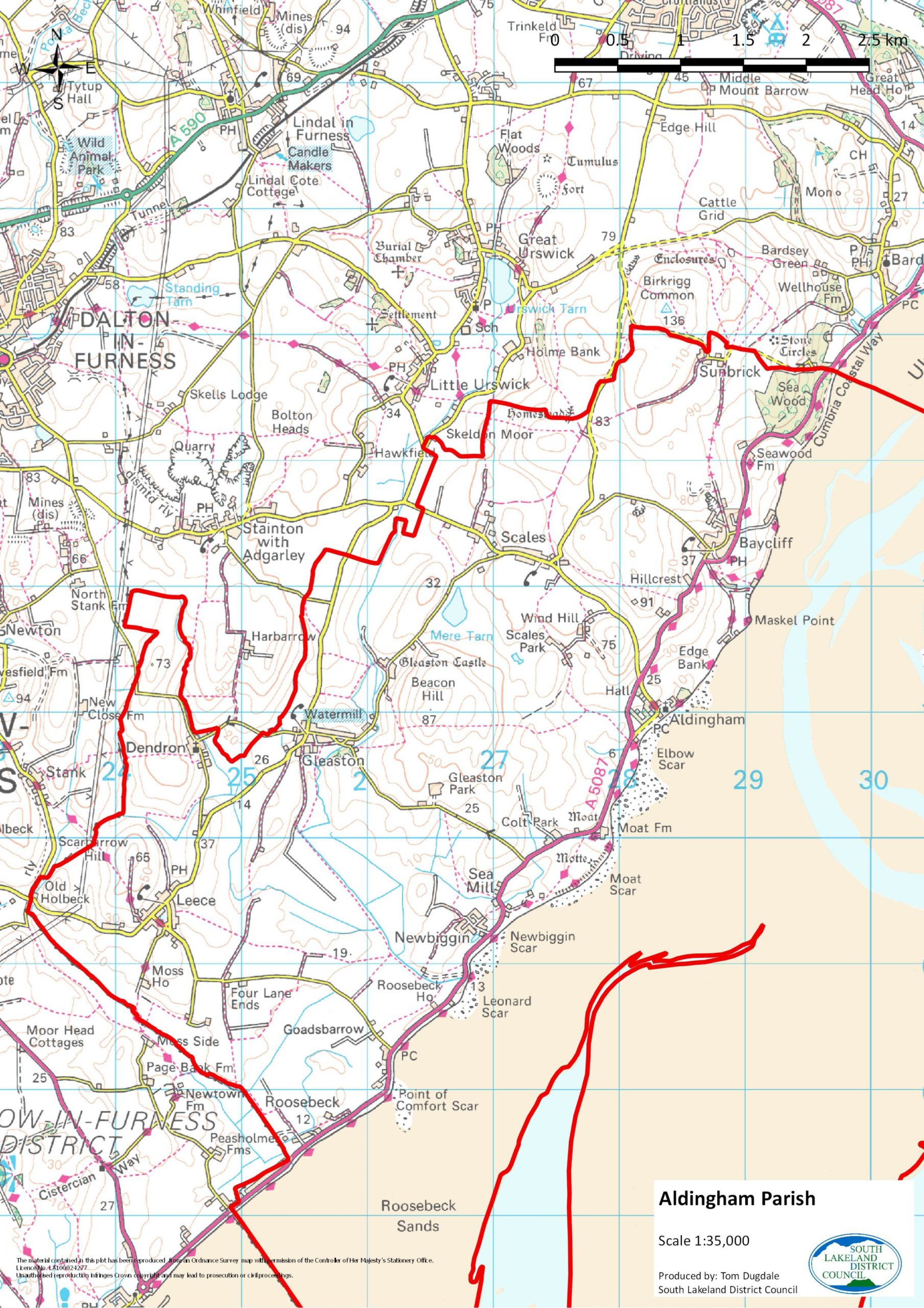
The parish of Aldingham lies on the eastern shores of the Furness Peninsula in south Cumbria, overlooking the sands of Morecambe Bay. The southernmost boundary is marked by Peasholmes Lane at the south end of Roosebeck and in the north the boundary follows the Seawood-Birkrigg road. The western boundary meanders irregularly through fields from Dove Cottage (called Old Holbeck on the map below) towards Greystone Lane, then south of Harbarrow towards Ulverston Road, then across Skeldon Moor towards Birkrigg and Sunbrick.
The parish boundaries extend into the sands of Morecambe Bay – indeed, more of the parish lies in the sands than on dry land.
Surrounding the parish to its south and west is the Borough of Barrow-in-Furness, whilst the parish of Urswick lies to the north. The towns of Ulverston and Dalton-in-Furness lie within a few miles of the parish boundaries.
The Villages
Aldingham is situated on the shores of Morecambe Bay. Anciently the administrative centre for Furness, today it is a small, quiet hamlet dominated by the massive Victorian mansion of Aldingham Hall, now a residential home for the elderly. Though one of the smallest villages in the Parish it boasts the 12th century Parish Church of St Cuthbert’s, the remains of a motte-and-bailey castle and the site of a moated manor house, both early homes of the Lords of Aldingham manor. The public toilets in the village were saved from closure in 2011 thanks to the generous donations of residents. The Parish Council is now working with the Friends of Aldingham Church to ensure the toilets remain open for future years.
Baycliff is one of the largest settlements in the Parish and nestles on a hillside a short distance from the coast. It owes its existence to farming and fishing and is still home to the Farmers Arms and Fishermans Arms. The village also has a playground maintained by the Baycliff Community Association. Close by, hidden down narrow country lanes, are the hamlets of Swinestead and Beanwell.
Dendron is a small hamlet on the west side of the Parish, lying quietly in a secluded valley. The 17th century Dendron Church overlooks the village and was once preached in by George Fox. The artist George Romney also went to school here. A short distance away is Dendron School, now two private houses, which closed down in 1994 and merged with Scales and Urswick to form Low Furness Primary School. Nearby is a war memorial commemorating all those from Dendron, Leece and Gleaston who fought in the First World War.
Gleaston is the one of the largest villages in the Parish. The historical sites of Gleaston Castle, the medieval home to the Lords of Aldingham, and the 18th century Gleaston Water Mill, now a tourist attraction, both lie to the north of the village. There is a playground, a large green and a village hall, all maintained by the Gleaston Village Hall and Green Committee.
Leece is situated around the calm waters of Leece Tarn which attracts several varieties of water fowl and has one of the highest breeding records for reed warblers in Cumbria. It is a unique Village by today’s standards as it retains it’s rural identity by having four working farms and an agricultural engineering company within it’s boundary.
Newbiggin is a small village not far from the coast, home to the ancient Sea Mill (now a house) and several caravan sites.
Roosebeck is a relatively modern settlement, which has grown up along the Coast Road at the very southern tip of the Parish. The village has fantastic panoramic views across Morecambe Bay. The hamlet of Goadsbarrow is situated nearby.
Scales is a long linear settlement, divided into two sections called ‘High Town’ and ‘Low Town’. The village is home to the Parish Hall (which used to be a Malt Kiln). This is Grade 11 listed, owned by the Church of England but run by the Community. Close by to Scales is the secluded Mere Tarn which is a haven for wildlife. There is a Village playground, owned by the Parish Council and maintained by the Scales Community Association.
Sunbrick is the northernmost settlement in the Parish, situated on the edge of Birkrigg Common. Though only a few houses and farms, the hamlet is the site of a Quaker Burial Ground in which Margaret Fell, one of its early pioneers, is buried. Close by is ‘the Druids’ Temple’, a concentric stone circle about 3,000 years old, and the ancient woodland of Sea Wood.